گروه دوچرخه سواری و طبیعتگردی آنادانا- همدان
هرکجا سازی شنیدی ، شعر و آوازی شنیدی، از دلی رازی شنیدی ، یاد ما کن.گروه دوچرخه سواری و طبیعتگردی آنادانا- همدان
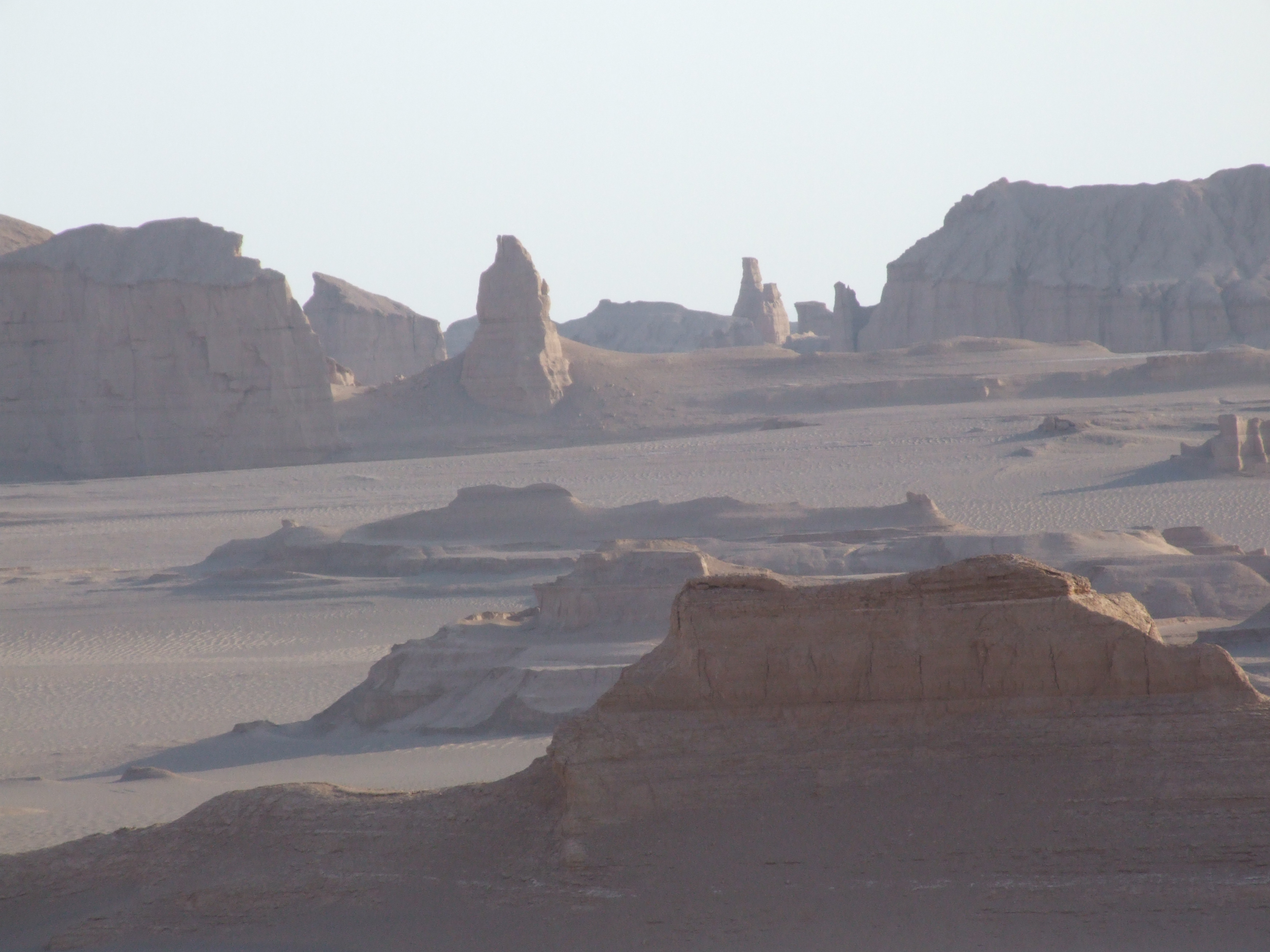
هرکجا سازی شنیدی ، شعر و آوازی شنیدی، از دلی رازی شنیدی ، یاد ما کن.سفر به کویر شهداد- قسمت اول
سلام . گزیده ای از سفرنامه کرمان و کویر شهداد
قسمت اول - روز اول و دوم :
روز دوشنبه صبح 20 مهرماه بعد از اینکه تو ترمینال اتوبوس همه جمع شدند از همدان به سمت تهران راه افتادیم و سفر دقیقاً از همین جا شروع شد.
قرار ما این بود که عصر همگی تو راه آهن تهران باشیم و همین هم شد و با پیوستن به بچه های تهران و کلی سلام و احوالپرسی به سمت قطار راهنمایی شدیم . سرپرست این برنامه آقای محمد شاهکرم بود که البته خیلی هم زحمت کشید. سفر با قطار جذاب و عالی بود که البته 14 یا 15 ساعت طول کشید . تو قطار کلی بگو بخند کردیم و سر به سر هم گذاشتیم .
صبح روز سه شنبه تو کرمان بودیم و با هماهنگی که محمد کرده بود با مینی بوس به سمت ماهان و باغ شاهزاده اون و مقبره شاه نعمت الله ولی و سیرچ و سرو چند هزار ساله اش رفتیم.
سرو دو هزار ساله سیرچ از دیدنی های این روستای دورافتاده است که البته کمتر کسی به ائن تئجه میکنه . وقتی کنار سرو ایستاده بودم به این فکر میکردم که اگه این سرو زبان داشت و روایت میکرد چقدر حرف برای گفتن داشت و چقدر آدم های بود که دیده بود و چقدر تجربه بود که میتوانست در اختیار ما بگذاره.
باغ شاهزاده ماهان هم یک موفقیت بزرگ در زمینه باغ سازی تو ایرانه که واقعاً متحیر کننده است. یک باغ ایرانی واقعی مربوط به دوران قاجار .
باغ شاهزاده ماهان :
باغ شاهزاده یکی از عالیترین و زیباترین باغهای سنتی ایران محسوب می شود . این باغ در نیم فرسنگی ماهان در دامنهکوههای تیگران جلوه گری می کند و از یادگارهای عبدالحمید میرزا فرمانفرما - حاکم کرمان در اواخر دوره قاجاریه است . گویند که جون خبر مرگ ناگهانی حاکم را به ماهان بردند بنایی که مشغول تکمیل سردر ساختمان بود تغار گچی را که بدست داشت محکم به دیوار کوبید و کار را رها کرده و فرار نمود آنطور که جای خالی کاشی ها همچنان بر سردرورودی خودنمایی می کند .
این باغ دارای سردر ورودی بسیار زیبا - عمارت شاه نشین و حمام می باشد . از قسمتهای ارزشمند باغ شکه آبرسانیو حوض های آن می باشد که در محور مرکزی باغ قرار دارد درجلوی عمارت اصلی حوض بزرگی با 5 فواره مشاهده می شود و آب این حوض که سرچشمه آن قنات معروف تیگران است به پاشویه سنگی اطراف آن ریخته و از آنجا به طرف ده شرشره آبشارگونه جاری می شود . این شبکه آبرسانی از نظر طراحی شاهکار محاسبه و دقت بشمار می رود . بازسازی باغ شاهزاده بعد از پیروزی انقلاب درسال 70 همزمان با برگزاری کنگره خواجوی کرمانی انجام گردید . در حال حاظر قسمت شاه نشین به یک رستوران مبدل گردیده و توسط بخش خصوصی اداره می گردد . این باغ دارای درختان میوه بسیاری از جمله انگور -آلو- آلوچه (گوجه سبز) - هلو - گردو و ... می باشد که در بین درختان زینتی جای گرفته و خودنمایی می کنند . هرساله گردشگران بسیاری از سراسر ایران وجهان برای بازدید از این باغ به ماهان می آیند و ساعتی را با آرامش و فارغ از دغدغه های زندگی سپری می نمایند .
درخت دوهزارساله روستای سیرچ:
سیرچ یکى از چهار آبادى بزرگ بخش شهداد است که در ناحیهٔ خوش آب و هواى کوهستانى بر سر راه شهداد - کرمان قرار گرفته است. فاصلهٔ آن تا شهر کرمان ۸۰ کیلومتر و تا مرکز بخش شهداد ۲۵ کیلومتر است. سیرچ از قدیم محل ییلاق بخش گرمسیرى و کویرى شهداد و آبادی هاى تابعهٔ آن بوده و بهارستان نام داشت. ییلاق مذکور در ارتفاع ۱۵۵۰ مترى در درهٔ رودى به همین نام قرار دارد و جمعیت آن در تابستان به علت موقعیت تفرجگاهى به بیش از ده هزار نفر می رسد.
سیرچ چشم اندازى زیبا، پوشیده از توده هاى انبوه درختان دارد. در مرکز سیرچ چندین درخت کهنسال سرو و چنار نیز وجود دارد." ولی یکی از این درختان بسیار کهنسال است. سیرچ زادگاه نویسنده مشهور هوشنگ مرادی کرمانی است و خانه ای که این نویسنده شهیر در آن بزرگ شده است در مجاورت همین درخت کهنسال است.دره سیرچ نیز در روز سیزده بدر پذیرای اهالی کرمان است. کمی آنطرف تر شهداد قرار دارد و دیدن کلوت های شهداد، قلعه شفیع آباد، آسیاب دو قلو شهداد و شهر کوتوله ها برای کوهنوردان جذابیت خاصی دارد.
مقبره شاه نعمت الله ولی :
بعد به سمت کمپ کویری به راه افتادیم که بسیار زیبا و خاطره انگیز بود و هیچگاه این کمپ زیبای کویری رو فراموش نخواهم کرد . کمپ کویری شهداد نزدیک روستای شفیع آباده .
شب برای دیدن آسمان زیبای کویری دلی به سرزمین های خشک زدیم که در این قسمت هم زیبا ٰ دوست داشتنی و ... عالی بود . اقیانوسی از ستاره .
deserts کویرها
This article is about arid terrain. For the act of abandoning or withdrawing support from an entity, see desertion. For other uses, see Desert (disambiguation).
Largest deserts
ills in the Judean desert
A desert is a landscape or region that receives almost no precipitation. Deserts are defined as areas with an average annual precipitation of less than 250 millimetres (10 in) per year,[1][2] or as areas where more water is lost by evapotranspiration than falls as precipitation.[3] In the Köppen climate classification system, deserts are classed as BWh (hot desert) or BWk (temperate desert). In the Thornthwaite climate classification system, deserts would be classified as arid megathermal climates.[4][5]
Terminology
Deserts are part of a wider classification of regions that, on an average annual basis, have a moisture deficit (i.e. they can potentially lose more than is received). Deserts are located where vegetation cover is sparse to almost nonexistent.[1][6]
Geography
A satellite image of the Sahara; the world's largest hot desert and third largest desert after Antarctica and the Arctic.
he snow surface at Dome C Station in Antarctica is representative of the majority of the continent's surface.
Deserts take up about one third (33 percent) of the Earth's land surface.[1] Hot deserts usually have a large diurnal and seasonal temperature range, with high daytime temperatures, and low nighttime temperatures (due to extremely low humidity). In hot deserts the temperature in the daytime can reach 45 °C/113 °F or higher in the summer, and dip to 0 °C/32°F or lower in the winter. Water acts to trap infrared radiation from both the sun and the ground, and dry desert air is incapable of blocking sunlight during the day or trapping heat during the night. Thus, during daylight most of the sun's heat reaches the ground, and as soon as the sun sets the desert cools quickly by radiating its heat into space. Urban areas in deserts lack large (more than 14 °C/25 °F) daily temperature variations, partially due to the urban heat island effect.
Many deserts are formed by rain shadows; mountains blocking the path of precipitation to the desert (on the lee side of the mountain). Deserts are often composed of sand and rocky surfaces. Sand dunes called ergs and stony surfaces called hamada surfaces compose a minority of desert surfaces. Exposures of rocky terrain are typical, and reflect minimal soil development and sparseness of vegetation. The soil is rocky because of the low chemical weathering.
Bottomlands may be salt-covered flats. Eolian processes are major factors in shaping desert landscapes. Cold deserts (also known as polar deserts) have similar features, except the main form of precipitation is snow rather than rain. Antarctica is the world's largest cold desert (composed of about 98 percent thick continental ice sheet and 2 percent barren rock). Some of the barren rock is to be found in the so-called Dry Valleys of Antarctica that almost never get snow, which can have ice-encrusted saline lakes that suggest evaporation far greater than the rare snowfall due to the strong katabatic winds that evaporate even ice.
The largest hot desert is the Sahara in northern Africa, covering 9 million square kilometres and 12 countries.
Deserts sometimes contain valuable mineral deposits that were formed in the arid environment or that were exposed by erosion. Due to extreme and consistent dryness, some deserts are ideal places for natural preservation of artifacts and fossils.
The 10 largest deserts | |||
Rank | Desert | Area (km²) | Area (mi²) |
1 | Antarctic Desert (Antarctica) | 13,829,430 | 5,339,573 |
2 | 13,700,000+ | 5,300,000+ | |
3 | Sahara (Africa) | 9,100,000+ | 3,320,000+ |
4 | Arabian Desert (Middle East) | 2,330,000 | 900,000 |
5 | Gobi Desert (Asia) | 1,300,000 | 500,000 |
6 | Kalahari Desert (Africa) | 900,000 | 360,000 |
7 | Patagonian Desert (South America) | 670,000 | 260,000 |
8 | Great Victoria Desert (Australia) | 647,000 | 250,000 |
9 | Syrian Desert (Middle East) | 520,000 | 200,000 |
10 | Great Basin Desert (North America) | 492,000 | 190,000 |
Etymology
he Thar Desert near Jaisalmer, India.
English desert and its Romance cognates (including Italian and Portuguese deserto, French désert and Spanish desierto) all come from the ecclesiastical Latin dēsertum (originally "an abandoned place"), a participle of dēserere, "to abandon." The correlation between aridity and sparse population is complex and dynamic, varying by culture, era, and technologies; thus the use of the word desert can cause confusion. In English prior to the 20th century, desert was often used in the sense of "unpopulated area", without specific reference to aridity; but today the word is most often used in its climate-science sense (an area of low precipitation)—and a desert may be quite heavily populated, with millions of inhabitants. Phrases such as "desert island" and "Great American Desert" in previous centuries did not necessarily imply sand or aridity; their focus was the sparse population. However, the connotation of a hot, parched, and sandy place often influences today's popular interpretation of those phrases.
adrart Acacus desert in western Libya, part of the Sahara.
Classification
In 1961, Peveril Meigs divided desert regions on Earth into three categories according to the amount of precipitation they received. In this now widely accepted system, extremely arid lands have at least 12 consecutive months without rainfall, arid lands have less than 250 millimeters (10 in) of annual rainfall, and semiarid lands have a mean annual precipitation of between 250 and 500 millimeters (10-20 in). Arid and extremely arid lands are deserts, and semiarid grasslands are generally referred to as steppes.[1]
Definition
Measurement of rainfall alone cannot provide an accurate definition of what a desert is because being arid also depends on evaporation, which depends in part on temperature. For example, Phoenix, Arizona receives less than 250 millimeters (10 in) of precipitation per year, and is immediately recognized as being located in a desert due to its arid adapted plants. However, the North Slope of Alaska's Brooks Range also receives less than 250 millimeters (10 in) of precipitation per year, and is not generally recognized as a desert region.[citation needed]
Potential evapotranspiration supplements the measurement of rainfall in providing a scientific measurement-based definition of a desert. The water budget of an area can be calculated using the formula P-PE±S, wherein P is precipitation, PE is potential evapotranspiration rates and S is amount of surface storage of water. Evapotranspiration is the combination of water loss through atmospheric evaporation and through the life processes of plants. Potential evapotranspiration, then, is the amount of water that could evaporate in any given region. As an example, Tucson, Arizona receives about 300 millimeters, (12 in), of rain per year, however about 2500 millimeters, (100 in), of water could evaporate over the course of a year.[citation needed] In other words, about 8 times more water could evaporate from the region than actually falls. Rates of evapotranspiration in cold regions such as Alaska are much lower because of the lack of heat to aid in the evaporation process.
There are different forms of deserts. Cold deserts can be covered in snow or ice; frozen water unavailable to plant life. These are more commonly referred to as tundra if a short season of above-freezing temperatures is experienced, or as an ice cap if the temperature remains below freezing year-round, rendering the land almost completely lifeless.
Most non-polar deserts are hot in the day and chilly at night (for the latitude) because of the lack of the moderating effect of water. In some parts of the world, deserts are created by a rain shadow effect in which air masses lose much of their moisture as they move over a mountain range; other areas are arid by virtue of being very far from the nearest available sources of moisture.
he Agasthiyamalai hills cut off Tirunelveli in India from the monsoons, creating a rainshadow region.
Deserts are also classified by their geographical location and dominant weather pattern as trade wind, mid-latitude, rain shadow, coastal, monsoon, or polar deserts. Former desert areas presently in non-arid environments are paleodeserts.
Montane deserts are arid places with a very high altitude; the most prominent example is found north of the Himalaya especially in Ladakh region of Jammu and Kashmir, in parts of the Kunlun Mountains and the Tibetan Plateau. Many locations within this category have elevations exceeding 3,000 meters (10,000 ft) and the thermal regime can be hemiboreal. These places owe their profound aridity (the average annual precipitation is often less than 40 mm/1.5in) to being very far from the nearest available sources of moisture. Montane deserts are normally cold.
Rain shadow deserts form when tall mountain ranges block clouds from reaching areas in the direction the wind is going. As the air moves over the mountains, it cools and moisture condenses, causing precipitation on the windward side. When that air reaches the leeward side, it is dry because it has lost the majority of its moisture, resulting in a desert. The air then warms, expands, and blows across the desert. The warm, desiccated air takes with it any remaining moisture in the desert.
Desert features
atellite view of Al-Dahna desert in Saudi Arabia showing different depositional features
Sand covers only about 20 percent of Earth's deserts. Most of the sand is in sand sheets and sand seas—vast regions of undulating dunes resembling ocean waves "frozen" in an instant of time. In general, there are six forms of deserts:
- Mountain and basin deserts
- Hamada deserts, which consist of plateau landforms
- Regs, which consist of rock pavements
- Ergs, which are formed by sand seas
- Intermontane Basins
- Badlands, which are located at the margins of arid lands comprising clay-rich soil
Nearly all desert surfaces are plains where eolian deflation—removal of fine-grained material by the wind—has exposed loose gravels consisting predominantly of pebbles but with occasional cobbles.
The remaining surfaces of arid lands are composed of exposed bedrock outcrops, desert soils, and fluvial deposits including alluvial fans, playas, desert lakes, and oases. Bedrock outcrops commonly occur as small mountains surrounded by extensive erosional plains.
Several different types of dunes exist. Barchan dunes are produced by strong winds blowing across a level surface and are crescent-shaped. Longitudinal or seif dunes are dunes that are parallel to a strong wind that blows in one general direction. Transverse dunes run at a right angle to the constant wind direction. Star dunes are star-shaped and have several ridges that spread out around a point.
Oases are vegetated areas moistened by springs, wells, or by irrigation. Many are artificial. Oases are often the only places in deserts that support crops and permanent habitation.
Flora and fauna
rickly pear flower
rgan Pipe cactus in Arizona
aguaros in the Sonoran Desert of Arizona
lora of Baja California Desert, Cataviña region, Mexico
Deserts have a reputation for supporting very little life, but in reality deserts often have high biodiversity, including animals that remain hidden during daylight hours to control body temperature or to limit moisture needs. Some fauna includes the kangaroo rat, coyote, jack rabbit, and many lizards. These animals adapted to live in deserts are called xerocoles. Many desert animals (and plants) show especially clear evolutionary adaptations for water conservation or heat tolerance, and so are often studied in comparative physiology, ecophysiology, and evolutionary physiology. One well-studied example is the specializations of mammalian kidneys shown by desert-inhabiting species.[7] Many examples of convergent evolution have been identified in desert organisms, including between cacti and Euphorbia, kangaroo rats and jerboas, Phrynosoma and Moloch lizards.
Some flora includes shrubs, Prickly Pears, Desert Holly, and the Brittlebush. Most desert plants are drought- or salt-tolerant, such as xerophytes. Some store water in their leaves, roots, and stems. Other desert plants have long taproots that penetrate to the water table if present, or have adapted to the weather by having wide-spreading roots to absorb water from a greater area of the ground. Another adaptation is the development of small, spiny leaves which shed less moisture than deciduous leaves with greater surface areas. The stems and leaves of some plants lower the surface velocity of sand-carrying winds and protect the ground from erosion. Even small fungi and microscopic plant organisms found on the soil surface (so-called cryptobiotic soil) can be a vital link in preventing erosion and providing support for other living organisms.
Deserts typically have a plant cover that is sparse but enormously diverse. The giant saguaro cacti of the Sonoran Desert provide nests for desert birds and serve as "trees" of the desert. Saguaro grow slowly but may live up to 200 years. When 9 years old, they are about 15 centimeters (6 in) high. After about 75 years, the cacti develop their first branches. When fully grown, saguaro cacti are 15 meters tall and weigh as much as 10 tons. They dot the Sonoran and reinforce the general impression of deserts as cactus-rich land.
Although cacti are often thought of as characteristic desert plants, other types of plants have adapted well to the arid environment. They include the pea and sunflower families. Cold deserts have grasses and shrubs as dominant vegetation.
Water
tacama, the world's driest desert[8]
he shifting sands simulator at Questacon, Canberra
Atacama is the driest place on Earth[8][9][10][11] and is virtually sterile because it is blocked from moisture on both sides by the Andes mountains and by the Chilean Coast Range. The cold Humboldt Current and the anticyclone of the Pacific are essential to keep the dry climate of the Atacama. The average rainfall in the Chilean region of Antofagasta is just 1 mm per year. Some weather stations in the Atacama have never received rain. Evidence suggests that the Atacama may not have had any significant rainfall from 1570 to 1971. It is so arid that mountains that reach as high as 6,885 metres (22,590 feet) are completely free of glaciers and, in the southern part from 25°S to 27°S, may have been glacier-free throughout the Quaternary, though permafrost extends down to an altitude of 4,400 metres and is continuous above 5,600 metres.
Rain does fall occasionally in deserts, and desert storms are often violent. A record 44 millimeters (1.7 in) of rain once fell within 3 hours in the Sahara. Large Saharan storms may deliver up to 1 millimeter per minute. Normally dry stream channels, called arroyos or wadis, can quickly fill after heavy rains, and flash floods make these channels dangerous. Though little rain falls in deserts, deserts receive runoff from ephemeral, or short-lived, streams fed considerable quantities of sediment for a day or two. Although most deserts are in basins with closed or interior drainage, a few deserts are crossed by 'exotic' rivers that derive their water from outside the desert. Such rivers infiltrate soils and evaporate large amounts of water on their journeys through the deserts, but their volumes are such that they maintain their continuity. The Nile River, the Colorado River, and the Yellow River are exotic rivers that flow through deserts to deliver their sediments to the sea. Deserts may also have underground springs, rivers, or reservoirs that lie close to the surface, or deep underground. Plants that have not completely adapted to sporadic rainfalls in a desert environment may tap into underground water sources that do not exceed the reach of their root systems.
Lakes form where rainfall or meltwater in interior drainage basins is sufficient. Desert lakes are generally shallow, temporary, and salty. Because these lakes are shallow and have a low bottom gradient, wind stress may cause the lake waters to move over many square kilometers. When small lakes dry up, they leave a salt crust or hardpan. The flat area of clay, silt, or sand encrusted with salt that forms is known as a playa. There are more than a hundred playas in North American deserts. Most are relics of large lakes that existed during the last ice age about 12,000 years ago. Lake Bonneville was a 52,000 kilometers² (20,000 mi²) lake almost 300 meters (1000 ft) deep in Utah, Nevada, and Idaho during the Ice Age. Today the remnants of Lake Bonneville include Utah's Great Salt Lake, Utah Lake, and Sevier Lake. Because playas are arid landforms from a wetter past, they contain useful clues to climatic change.
When the occasional precipitation does occur, it erodes the desert rocks quickly and powerfully.
The flat terrains of hardpans and playas make them excellent racetracks and natural runways for airplanes and spacecraft. Ground-vehicle speed records are commonly established on Bonneville Speedway, a racetrack on the Great Salt Lake hardpan. Space shuttles land on Rogers Lake Playa at Edwards Air Force Base in California.
Formation of hot deserts
There are three main, interlinked causes of hot deserts:[citation needed]
- The formation of the subtropical high-pressure cell.
- The rain shadow effect in the belt of easterly trade winds.
- The effect of the cold currents off the west coast of the continents at these latitudes.
- The depositing sands of a desert along it's border into the fertile land
It must be noted that also hot deserts (like cold deserts) may result in average temperature cooling [3] because they reflect more of the incoming light (their albedo is higher than that of water or forests).
Mineral resources
mining plant near Jodhpur, India
Deserts may contain great amount of mineral resources over their entire surface. This occurrence in minerals also determines the color. For example, the red color of many sanddeserts is a result of the occurrence of laterite. [12]
Some mineral deposits too are formed, improved, or preserved by geologic processes that occur in arid lands as a consequence of climate. Ground water leaches ore minerals and redeposits them in zones near the water table. This leaching process concentrates these minerals as ore that can be mined.
Evaporation in arid lands enriches mineral accumulation in their lakes. Lake beds known as playas may be sources of mineral deposits formed by evaporation. Water evaporating in closed basins precipitates minerals such as gypsum, salts (including sodium nitrate and sodium chloride), and borates. The minerals formed in these evaporite deposits depend on the composition and temperature of the saline waters at the time of deposition.
Significant evaporite resources occur in the Great Basin Desert of the United States, mineral deposits made famous by the "20-mule teams" that once hauled borax-laden wagons from Death Valley to the railroad. Boron, from borax and borate evaporites, is an essential ingredient in the manufacture of glass, enamel, agricultural chemicals, water softeners, and pharmaceuticals. Borates are mined from evaporite deposits at Searles Lake, California, and other desert locations. The total value of chemicals that have been produced from Searles Lake substantially exceeds US$1 billion.
The Atacama Desert of Chile is unique among the deserts of the world in its great abundance of saline minerals. Sodium nitrate has been mined for explosives and fertilizer in the Atacama since the middle of the 19th century. Nearly 3 million tonnes were mined during World War I.
Valuable minerals located in arid lands include copper in the United States, Chile, Peru, and Iran; iron and lead-zinc ore in Australia; and gold, silver, and uranium deposits in Australia and the United States. Nonmetallic mineral resources and rocks such as beryllium, mica, lithium, clays, pumice, and scoria also occur in arid regions. Sodium carbonate, sulfate, borate, nitrate, lithium, bromine, iodine, calcium, and strontium compounds come from sediments and near-surface brines formed by evaporation of inland bodies of water, often during geologically recent times.
The Green River Formation of Colorado, Wyoming, and Utah contains alluvial fan deposits and playa evaporites created in a huge lake whose level fluctuated for millions of years. Economically significant deposits of trona, a major source of sodium compounds, and thick layers of oil shale were created in the arid environment.
Some of the more productive petroleum areas on Earth are found in arid and semiarid regions of Africa and the Mideast, although the oil fields were originally formed in shallow marine environments. Recent climate change has placed these reservoirs in an arid environment. It's noteworthy that Ghawar, the world's largest and most productive oilfield is mostly under the Empty Quarter and Al-Dahna deserts.
Other oil reservoirs, however, are presumed to be eolian in origin and are presently found in humid environments. The Rotliegendes, a hydrocarbon reservoir in the North Sea, is associated with extensive evaporite deposits. Many of the major U.S. hydrocarbon resources may come from eolian sands. Ancient alluvial fan sequences may also be hydrocarbon reservoirs.
Solar energy resources
Deserts are increasingly seen as sources for solar energy. The Negev Desert and the surrounding area, including the Arava Valley, are the sunniest parts of Israel and little of this land is arable, which is why it has become the center of the Israeli solar industry.[13] David Faiman, a world expert on solar energy, feels the energy needs of a country like Israel could be met by building solar energy plants in the Negev.[14] Faiman also feels the technology now exists to supply all of the world's electricity needs with 10 per cent of the Sahara Desert.[14] Solel has nine fields of solar collectors in the Mojave Desert of California.[15] It recently signed a contract to build the Mojave Solar Park, which will be the world's largest solar generating plant.[16][17]
Human life in deserts
ahktesh Gadol, an erosional basin in the Negev Desert of southern Israel
ooking in desert
A desert is a hostile, potentially deadly environment for unprepared humans. In hot deserts, high temperatures cause rapid loss of water due to sweating, and the absence of water sources with which to replenish it can result in dehydration and death within a few days. In addition, unprotected humans are also at risk from heatstroke.
Humans may also have to adapt to sandstorms in some deserts, not just in their adverse effects on respiratory systems and eyes, but also in their potentially harmful effects on equipment such as filters, vehicles and communication equipment. Sandstorms can last for hours, sometimes even days. This makes surviving in the desert quite difficult for humans.
Despite this, some cultures have made hot deserts their home for thousands of years, including the Bedouin, Tuareg tribe and Pueblo people. Modern technology, including advanced irrigation systems, desalinization and air conditioning have made deserts much more hospitable. In the United States and Israel for example, desert farming has found extensive use.
In cold deserts, hypothermia and frostbite are the chief hazards, as well as dehydration in the absence of a source of heat to melt ice for drinking. Falling through pack-ice or surface ice layers into freezing water is a particular danger requiring emergency action to prevent rapid hypothermia. Starvation is also a hazard; in low temperatures the body requires much more food energy to maintain body heat and to move. As with hot deserts, some people such as the Inuit have adapted to the harsh conditions of cold deserts.
Most traditional human life in deserts is nomadic. It depends in hot deserts on finding water, and on following infrequent rains to obtain grazing for livestock. In cold deserts, it depends on finding good hunting and fishing grounds, on sheltering from blizzards and winter extremes, and on storing enough food for winter. Permanent settlement in both kinds of deserts requires permanent water and food sources and adequate shelter, or the technology and energy sources to provide it.
Many deserts are flat and featureless, lacking landmarks, or composed of repeating landforms such as sand dunes or the jumbled ice-fields of glaciers. Advanced skills or devices are required to navigate through such landscapes and inexperienced travellers may perish when supplies run out after becoming lost. In addition sandstorms or blizzards may cause disorientation in severely reduced visibility.
The danger represented by wild animals in deserts has been featured in explorers' accounts but does not cause higher rates of death than in other environments such as rain forests or savanna woodland, and generally does not by itself affect human distribution. Defence against polar bears may be advisable in some areas of the Arctic, as may precautions against venomous snakes and scorpions in choosing sites at which to camp in some hot deserts.
See also
olob Canyon, part of Zion National Park, Utah, United States is part of the larger desert the Colorado Plateau.
- List of deserts by area (size)
References
- ^ "desert". Encyclopædia Britannica online. http://www.britannica.com/eb/article-70815/desert. Retrieved 2008-02-09.
- ^ Fredlund, D.G.; Rahardjo, H. (1993) (pdf). Soil Mechanics for Unsaturated Soils. Wiley-Interscience. ISBN 978-0471850083. http://www.soilvision.com/subdomains/unsaturatedsoil.com/Docs/chapter1UST.pdf. Retrieved 2008-05-21.
- ^ Al-kahtani, M.A.; C. Zuleta, E. Caviedes-Vidal, and T. Garland, Jr. (2004). "Kidney mass and relative medullary thickness of rodents in relation to habitat, body size, and phylogeny". Physiological and Biochemical Zoology 77: 346-365. http://www.biology.ucr.edu/people/faculty/Garland/Al-kahtaniEA2004.pdf.
- ^ Boehm, Richard G.; ors and writers of The World and Its People (2006). The World and Its People (2005 ed.). Columbus, Ohio: Glencoe. pp. 276. ISBN 0-07-860977-1.
- ^ Tsjaad by Dorrit van Dalen
- ^ Head of Kibbutz Movement: We will not be discriminated against by the government, Ehud Zion Waldoks, Jerusalem Post, March 10, 2008.
- ^ a b Giant solar plants in Negev could power Israel's future, John Lettice, The Register, January 25, 2008
- ^ [1]
یک یا علی دیگر
سلام. یادتون میاد تو اردیبهشت یه برنامه داشتیم و رفتیم یه کتابخانه روستایی رو تجهیز کردیم ؟
یادتون میاد چقدر به ما کمک کردید؟
یادتون میاد چقدر بچه های اون روستا خوشحال شدند؟
حالا که مدرسه ها دوباره باز شده یه یا علی دیگر میخواهیم تا کسری کتابهای کتابخانه رو تکمیل کنیم .
دوباره منتظر حرکت خیرخواهانه شما هستیم . تا نهال دانش رو تو یک نقطه محروم سیراب کنیم .
« حتی یک کتاب » هم میتواند به این حرکت خیرخواهانه کمک کنه .
یا مثل آقای سید جلیل فداکار و بقیه بچه های شرکت توسعه و آبادانی جزیره کیش که کمک خوبی در فاز اول کردند . مبالغی رو « حتی 1000 تومان » به شماره حساب 0100643599002 بانک کشاورزی به نام آرش خزایی واریز کنند تا به نیابت از ایشان کتابهای مورد نظرشون رو بخریم.شماره روی کارت برای دوستانی هم که میخواهند از طریق دستگاههای ATM واریز کنند6037701010944533 می باشد.
ممنون و متشکر
یک حادثه
به گزارش خبرگزاری محیطزیست ایران دوشنبه هفته پیش در حالیکه عباس جعفری با یک قایق کایاک یک نفره در یکی از رودخانههای نپال در حال قایق سواری بود، دچار حادثه شده. قایق او برگشته و از دسترس همراهان خارج شده است.
از دوشنبه تا لحظه نگارش این خبر جستوجوها فقط منجر به پیدا کردن قایق عباس در مرز کشور چین و نپال شده است و هنوز اثری از خود او به دست نیامده.
عباس جعفری در 25 سال گذشته در زمینههای مختلفی چون عکاسی، راهنمای گردشگری، کوه نوردی و تدریس اکوتوریسم فعالیت میکرد.
جعفری متولد 1341 است و به بیشتر قلههای بالای 7 هزار متر جهان صعود کرده و یکی از سرشناسترین کوه نوردان ایران محسوب میشود.
عکسهای او از طبیعت و مردم ایران و جهان در معتبرترین نشریات بینالمللی (ازجمله نشنال ژئوگرافیک) چاپ شده و نیز عکسهای کتاب "راه یاب ایران" نیز منبعی است از تصاویری که جعفری در طول سفر از گوشه و کنار ایران گرفته است.
او روزنامهنگاری را با مجله شکار و طبیعت پیشین آغاز کرده و همیشه سفرنامهها و یادداشتها و عکسهای وی در معتبرترین نشریات گردشگری کشور چاپ شده است.
وی نقش قابلتوجهی در شناسایی بسیاری از مناطق دور افتاده و مردم بومی ایران داشـــته و میتوان گفت بسیاری از آیینهای ایرانی به واسطه تلاش عباس جعفری بوده که اقبال ثبت و ماندگاری پیدا کرده است.
از جعفری هماکنون کتاب راه یاب بیابانگردی در ایران از سوی انتشارات فرهنگ معاصر در مرحله تدوین نهایی قرار دارد.
وی تاکنون عمدتا بهعنوان راهنمای سفر فعال بوده و در حال حاضر دبیر گروه اکوتوریسم خبرگزاری محیطزیست ایران (ایرن) است.
جعفری ازجمله همکاران روزنامه همشهری بوده وعکسهای زیبای اوازطبیعت ایران بارها درصفحه اول همشهری چاپ شده است .همچنان جستوجوها برای یافتن عباس ادامه دارد. برای نجات او دعا کنیم. کاری جز این نمیتوان کرد.
رادیوی سراسری نپال هر چند لحظه یک بار مشخصات عباس را اعلام کرده و از مردم محلی می خواهند در صورت یافتن نشانه ای از او به گروه های جستجو اطلاع دهند. تلویزیون نپال نیز چندین بارتصویر عباس را نشان داده و برای یافتن او از مردم این کشور استمداد طلبیده است. عباس جعفری اکوتوریست، کوه نورد و عکاس نامدار ایرانی از دوشنبه گذشته در چین کایاک سواری در رودخانه تریشولی نپال به دام یک گرداب افتاده و مفقود شده است. قایق او در نزدیکی محل حادثه ( دو و نیم کیلومتر) اما با وجود جستجوهای گسترده هنوز نشانه ای از خود او پیدا نشده است.
پس از اعلام خبر مفقود شدن عباس دوتن از دوستانش محمد تاجران و محمد علیان عازم نپال شدند و تیم جستجو را از لحاظ مالی، روحی و تجهیزات تقویت نمودند . در حال حاضر دو تیم 10 نفره به تیم جستجو افزوده شده است. مسیر رودخانه و مسیرهای فرعی و همچنین جنگل های حاشیه رودخانه و قبایل اطراف باید مورد بررسی و جستجو قرار گیرد. نپالی ها و تیم جستجو به یافتن عباس و زنده بودنش امیدوارند و نمونه های از این دست در این منطقه توسط جستجوگران یافته شده است علاوه بر این به دلیل اینکه عباس جعفری خود مدرس " زندگی در شرایط سخت" بوده است همچنین با توجه به وسعت منطقه و انشعاب های فراوان رودخانه و پوشش جنگلی اطراف آن احتمال زنده ماندن او هنوز وجود دارد.
24/6/88 جستجو برای یافتن عباس همچنان ادامه دارد. تیم جستجو سوم نیز منطقه را بار دیگر مورد چیمایش و جستجو قرار می دهد. همچنین تایید شد که قابق عباس در فاصله دو و نیم کیلومتری محل حتادثه پیدا شده و یافتن قایق در مرز چین که در خبرهای اولیه امده بود منتفی است.
یوسف گم گشته بازاید به کنعان غم مخور
25/6/88
به گزارش تیم تجسس منطقه نپال دیروز (سه شنبه 24 شهریور) جسد یک مرد و یک زن در حاشیه رودخانه کشف گردید. جسد مرد که دارای صورتی سالم بود توسط خانم فرخنده صادق - همسر عباس جعفری - مورد شناسایی قرار گرفت و مشخص گردید که جسد مکشوفه متعلق به عباس جعفری نمی باشد. لذا اخبار و شایعات منتشره درخصوص یافتن پیکر وی تایید نمی گردد.
رودخانه عریض و طویل تیل چو با عرض بین 200 تا 1000 متر و طولی حدود 200 کیلومتر پس از عبور از مناطق مختلف جنگلی و مردابها به اقیانوس هند می ریزد. حوادث غرق و مفقود شدن در این منطقه پرخطر زیاد اتفاق می افتد و سابقه پیداشدن جسد یا فرد زنده پس از روزهای طولانی در این منطقه وجود دارد.
مسئولین تیم های تجسس حاضر در منطقه پس از کشف این دو جسد، با انرژی مضاعف به جستجوی خویش برای دستیابی به خبرهای خوشحال کننده ای از وضعیت مربی و هنرمند گرانقدر کشورمان - عباس جعفری - پرداختند.
همچنین محل اولیه ناپدید شدن وی که امکان غواسی داشته است توسط تیم غواسی مورد کاوش قرار گرفت و به دلیل عدم یافتن ردی از وی امید نجات عباس بیش از پیش شده است.
27/6/88 طی تماس برقرار شده با تیم جستجو اعلام شد که منطقه همچنان مورد بررسی و جستجو قرار دارد و امید در تیم و همه دوستداران عباس پرشور است.
28/6/88 عملیات در بخش اول از محدوده های سه گانه تعیین شده برای جستجو پایان یافته و گروه های نجات بر محدوده دوم متمرکز شده اند . بخش اول شامل خود رودخانه می شده است، یعنی جایی که از بیشترین احتمال برای یافتن عباس برخورداربوده، بخش دوم محدوده ای با امکان متوسط را در بر می گیرد، که عمدتاً شامل حوزه های پایین دست و مناطق جنگلی اطراف رودخانه می شود. بخش سوم با احتمال " کم " شامل محدوده های دورتر از رودخانه می شود. نیافتن نشانه ای از عباس در محدوده شماره یک، می تواند خبری امیدوارکننده هم محسوب شود، زیرا این احتمال را که عباس رودخانه را ترک کرده و توسط خود و شاید بومیانی که او را پیدا کرده باشند، به جایی درخشکی منتقل شده باشد، افزایش می دهد .
امشب نیز تیم جستجو با افراد محلی و حرفه ای نپالی جلسه ای برای بررسی منطقه و احتمالا تغییر نحوه جستجو خواهند داشت که روند را بهتر و سریع تر نمایند. نتیجه این جلسه به زودی اطلاع رسانی خواهد شد
29/6/88 غروب، امروز تیم جستجو طی برنامه از پیش اعلام شده جستجوی خانه به خانه سمت راست رودخانه را آغاز کرده اند. هنوز اثری از عباس نیست.تیم جستجو در حال حاضر شامل فرخنده، همسر عباس و سایر دوستان او از ایران و تعدادی از راهنمایان محلی بوده که جمعا نزدیک 20 نفر هستند.از فردا تعداد بیشتری به این تیم ملحق خواهند شد.تیم نجات کشور نپال تنها در جستجوی رودخانه شرکت داشت و جستجوی خانه به خانه و خشکی به دوش عزیزان ایرانی خودمان است.از اینجا به همه آنان خسته نباشید می گوییم و امیدواریم تلاششان بی پاسخ نماند.
برای سلامتی عباس ، فرخنده و دوستان پر تلاشمان دعا می کنیم.
30/6/88 دوستان عزیز...
عملیات جستجو، امروز در قالب دو تیم، یکی بر روی رودخانه و دیگری در خشکی مطابق برنامه صورت گرفته است.هیچ سر نخی از عباس عزیزمان نیست. اما ما این را به فال نیک گرفته و همچنان امیدواریم که عباس خود را از رودخانه خارج کرده و شاید جایی در خشکی تحت مداواست. برای عباس ، فرخنده، محمد تاجران ،محمد علیان ،کامران، سعیده و بدری عزیز دعا می کنیم.